
The Lost Rivers and Canals of Thanjavur
The Lost Rivers and Canals of Thanjavur
Introduction: How Water Shaped the City
When people think of Thanjavur, they usually think of the Brihadisvara Temple, Chola architecture, Thanjavur paintings, classical music, fertile paddy fields and the Cauvery.
But there is another story running quietly underneath all of them.
It is the story of water.
Long before modern roads divided the landscape and concrete buildings covered parts of the old agricultural town, Thanjavur was shaped by a remarkable network of rivers, branches, canals, channels, tanks and irrigation structures.
Some of these waterways are still important today.
Others have become smaller, changed course, been incorporated into modern irrigation systems, or disappeared from everyday conversation.
Yet they helped determine where people cultivated rice, where villages developed, how water reached fields and why the Cauvery delta became one of the most productive agricultural regions of Tamil Nadu.
The official Thanjavur District administration describes the district’s irrigation system as being supplied through the Cauvery and its branches, with water regulated through structures including the Grand Anicut and distributed through the Cauvery, Vennar and Grand Anicut Canal systems. [Thanjavur District]
So when we talk about the history of Thanjavur, we should not look only at its palaces and temples.
We should also follow the water.
A City Built in a Delta
Thanjavur lies within the Cauvery delta, a landscape created by the river and its many branches.
The Central Ground Water Board describes Thanjavur as part of the Cauvery river basin, with the Vennar and Vettar sub-basins. The district forms part of the delta created by the Cauvery, with a gentle slope towards the east and southeast. ([Central Ground Water Board][2])
This geography is crucial.
The Cauvery does not behave like a single river passing through the district and then simply disappearing into the sea.
Instead, water divides and divides again.
At the Grand Anicut, the river system is regulated and distributed into different branches. The Cauvery subsequently divides into numerous channels, creating an extensive irrigation network across the delta. [Central Water Commission]
That network is one of the reasons the landscape around Thanjavur looks the way it does today.
The paddy fields are not separate from the waterways.
They are the product of the waterways.
Kallanai: The Beginning of a Much Bigger Story
Any discussion of Thanjavur’s water history eventually leads to the Grand Anicut, or Kallanai.
The structure is traditionally attributed to Karikala Chola and dates to the early centuries of the Common Era. The International Commission on Irrigation and Drainage identifies Kallanai as a 2nd-century AD structure designed to divert Cauvery water across the fertile delta for irrigation. [ICID]
Kallanai is remarkable not simply because it is old.
Its importance lies in what it made possible.
Water could be diverted and distributed across a much larger agricultural landscape.
The Central Water Commission’s historical account describes the Cauvery system downstream of the Upper Anicut and Grand Anicut as dividing into branches, including the Cauvery and Vennar, with further channels and regulators distributing water throughout the delta. [Central Water Commission]
In other words, Kallanai should not be thought of as an isolated ancient dam.
It became part of a much larger water-distribution system.
And that system eventually became extraordinarily complicated.
Thanjavur Had More Than One “River”
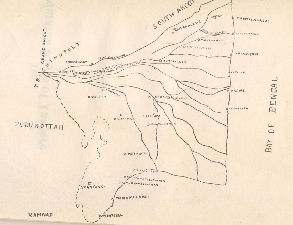
One of the fascinating things about researching Thanjavur’s water history is discovering just how many names appear on old irrigation records and modern agricultural documents.
The Thanjavur District Agricultural Plan lists a long series of rivers and branches associated with the district’s irrigation system, including:
* Cauvery
* Vennar
* Vettar
* Kodamurtiyar
* Pannaiyar
* Koraiyar
* Thirumalairajanar
* Veerasozhanar
* Arasalar
* Mudikondan
* Noolar
* Nattar
* Nandalar
* Vadavar
* Puthar
* Pamaniar
* Mulliyar
* Ayyanar
* Adappar
* Harichandranathi
* Vellaiyar
* Pandavaiyar
* Odambogiyar
* Kattar
* Kaduvaiyar
The same government agricultural document notes that these waterways and their branches were important sources of irrigation for the district. [Agritech TNAU]
That list tells us something important.
What looks like a simple river landscape on a modern map was actually a vast web of waterways.
Some were major branches.
Some were canals.
Some functioned as irrigation channels.
Some were connected to anicuts and regulators.
And many eventually divided into smaller channels that carried water towards individual agricultural areas.
Vennar and Vettar: The Branches That Helped Feed the Delta
The Vennar is particularly important in understanding the agricultural geography of Thanjavur.
Government groundwater documentation records that the Grand Anicut is located at the western boundary of the district, where the Cauvery divides into the Cauvery and Vennar. It also records further divisions, including the Vennar splitting into Vennar and Vettar at Thenperumbur anicut. [Sarguru Tech]
This is the basic principle behind the delta:
one river becomes many waterways, and many waterways serve many fields.
The result is a landscape where water is rarely far from agriculture.
The Thanjavur District Agricultural Plan recorded canals as a major source of irrigation, with canal irrigation accounting for a substantial share of the district’s irrigated area. [Agritech TNAU]
The importance of canals therefore wasn’t merely historical.
They continued to determine agricultural productivity well into the modern period.
The Canals You May Not Notice Anymore
Walk around Thanjavur today and it is easy to think of the city as a collection of roads, buildings, shops and residential neighbourhoods.
But the older landscape tells another story.
Many waterways do not look dramatic.
There is no enormous monument beside them.
There may be no signboard explaining their history.
Some appear simply as narrow channels alongside fields or roads.
Others have been modified as part of modern irrigation and drainage systems.
That makes them easy to overlook.
But historically, a small vaykkal could be extremely important.
It could carry water from a larger branch to a tank, from a tank towards agricultural land, or from one part of an irrigation network to another.
The word “canal” therefore does not necessarily mean one huge engineered waterway.
The traditional irrigation landscape depended upon networks of different sizes.
The major branches supplied smaller channels.
The smaller channels supplied agricultural areas.
And the water eventually reached individual fields.
The Grand Anicut Canal Changed Southern Thanjavur
There is another chapter in this story that is particularly important because it is comparatively recent.
The southern parts of the Thanjavur region did not historically enjoy the same natural abundance of Cauvery water as the northern delta.
Large areas depended more heavily on rainfall.
That changed with the development of the Grand Anicut Canal, also known as the Puthu Aru.
A recent report by DT Next describes how the Grand Anicut Canal transformed parts of southern Thanjavur that had previously depended heavily on rain-fed agriculture. The canal was developed as part of the Cauvery-Mettur project and began changing the agricultural landscape of southern Thanjavur in the 1930s. [DT Next]
This is an important reminder that Thanjavur’s water landscape was not created entirely in ancient times.
It continued to evolve.
Ancient structures were repaired and modified.
New regulators were constructed.
New canals were created.
Old irrigation systems were connected to newer engineering projects.
The landscape we see today is therefore the result of many different periods of water engineering layered on top of one another.
From Ancient Water Management to Modern Irrigation
The story of Thanjavur’s waterways is also a story of technological change.
The Public Works Department’s Thanjavur documentation explains that water released from the Mettur system reaches the Grand Anicut, where it is regulated and distributed into the Cauvery, Vennar, Grand Anicut Canal and other systems serving the delta. ([Thanjavur District][1])
Modern regulators, sluices and irrigation structures now control water distribution.
But the basic challenge remains remarkably familiar:
How do you take water from a river and deliver the right amount to agricultural land at the right time?
That question existed centuries ago.
The technology changed.
The scale changed.
The administrative system changed.
But the fundamental problem remained the same.
The Cholas Understood That Water Was Wealth
The connection between Chola power and irrigation is often reduced to the famous Kallanai story.
But water management was much broader than one structure.
Historical research on Chola irrigation describes networks of channels, tanks, sluices and other structures used to move and regulate water. [Scribd]
There is also archaeological evidence showing that water management involved local participation.
A Chola-period inscription dated to the reign of Rajaraja I, around 1009 AD, records the construction of a stone sluice for irrigation. Archaeologists studying the inscription highlighted the role of individuals and local communities in water management. [The Times of India]
That is an interesting detail because it changes the way we imagine ancient irrigation.
It was not simply a king ordering a giant dam to be built.
Water management could involve:
kings + local authorities + landholders + farmers + engineers + communities.
The survival of agriculture depended upon the entire system functioning together.
What Happened to the Old Waterways?
This is where the story becomes more difficult.
It is tempting to call every old channel that has disappeared a “lost river.”
But historically, that would be misleading.
Some waterways have genuinely changed.
Others still exist but have different functions.
Some have become seasonal.
Some have been incorporated into modern irrigation systems.
Some smaller channels have been affected by changes in agriculture, urbanisation, roads and drainage.
And some names survive even when the physical watercourse is no longer obvious.
That distinction matters.
A waterway disappearing from everyday visibility does not necessarily mean that it has completely vanished from the landscape.
Sometimes the name survives longer than the river itself.
Sometimes the channel survives beneath a modern road or beside a developed neighbourhood.
And sometimes an old agricultural boundary still hints at the route water once followed.
This is one reason the old maps of Thanjavur deserve much more attention.
Look at Thanjavur Through Water, Not Just Roads
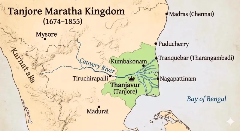
There is a different way to read the city.
Instead of asking:
“Where is this road going?”
ask:
“Where did the water used to go?”
Instead of looking only at temples, palaces and historic buildings, look at:
* old channels
* bridges
* sluices
* anicuts
* irrigation tanks
* field boundaries
* drainage channels
* low-lying areas
* old village names
* traditional agricultural settlements
These features can reveal another version of Thanjavur.
A city whose history was not written only in stone.
It was also written in water.
Why Thanjavur Became the Rice Bowl
The phrase “Rice Bowl of Tamil Nadu” is often used to describe Thanjavur.
But the phrase becomes more meaningful when we understand the infrastructure behind it.
The Cauvery provided the fundamental water source.
Kallanai helped divert and regulate that water.
Branches such as the Vennar and Vettar carried water further into the delta.
Canals and smaller channels distributed it.
Regulators controlled flows.
Fields were shaped around the availability of water.
Farmers cultivated rice in a landscape that had been progressively organised around irrigation.
This is why the agricultural identity of Thanjavur cannot be separated from its water history.
The paddy field is the visible result.
The canal is part of the hidden infrastructure behind it.
A Water Network Larger Than We Imagine
The scale becomes clearer when we look at the official descriptions.
The Thanjavur district administration states that water at the Grand Anicut is distributed through the Cauvery, Vennar and Grand Anicut Canal systems to serve a command area of about 4.53 lakh acres. [Thanjavur District]
That is not simply a river.
It is an engineered landscape.
And the system continues to be maintained today.
The district’s Water Resources Department lists separate engineering divisions associated with the Cauvery, Agniyar, Grand Anicut Canal and Vennar systems. [Thanjavur District]
So even in the 21st century, the old relationship between Thanjavur and water remains very much alive.
The Rivers Are Still Writing Thanjavur’s Story
Perhaps the most interesting thing about Thanjavur’s waterways is that their story is not finished.
Every year, the arrival and distribution of Cauvery water affects agriculture.
Farmers watch water levels.
Canals are maintained.
Regulators are operated.
Fields are prepared.
Paddy is planted.
And the agricultural cycle begins again.
The same basic landscape that helped make Thanjavur important centuries ago continues to influence life today.
That is why the old canals should not be treated merely as historical curiosities.
They are part of the living heritage of Thanjavur.
The Next Time You Travel Through Thanjavur…
The next time you cross a small bridge outside the city, notice the channel underneath.
The next time you drive past a paddy field, look for the canal that feeds it.
When you see a sluice or regulator, remember that it is part of a much larger system.
And when you hear someone say that Thanjavur is the Rice Bowl of Tamil Nadu, remember that the story begins long before the rice reaches the plate.
It begins with the river.
Then the river becomes a branch.
The branch becomes a canal.
The canal becomes a smaller channel.
The channel reaches a field.
And that field becomes part of the landscape that generations of people have called Thanjavur.
The history of Thanjavur is not only carved into its temples.
Some of it is still flowing through its waterways.
A Note About the Word “Lost”
The term “lost rivers” in this article is used in a broader historical sense. Not every waterway discussed here has disappeared physically. Some remain active irrigation channels or branches, while others have changed over time or are less visible in the modern landscape.
That distinction is important because Thanjavur’s water system is a continuously evolving network rather than a collection of rivers that simply appeared and disappeared.
Sources & Further Reading
For an article like this, I recommend keeping the references visible at the bottom rather than hiding them. It strengthens the site’s credibility and supports the local-history identity you are building.
Government & institutional sources
Thanjavur District Administration – Water Resources Department / PWD
Provides current information on the Cauvery, Grand Anicut, Vennar, Grand Anicut Canal and the irrigation command area.
[Thanjavur District Administration – PWD / Water Resources Department] (https://thanjavur.nic.in/pwd-water-resources-department-wrd/?utm_source=chatgpt.com)
Central Ground Water Board – Thanjavur District Report
Useful for understanding the district’s basin, drainage pattern, rivers, branches and groundwater context.
[Central Ground Water Board – Thanjavur District] (https://cgwb.gov.in/sites/default/files/2022-10/thanjavur.pdf?utm_source=chatgpt.com)
Tamil Nadu Agricultural University – District Agricultural Plan: Thanjavur
Particularly valuable for the historical list of rivers, branches and irrigation sources across the district.
[Tamil Nadu Agricultural University – Thanjavur District Agricultural Plan](https://www.agritech.tnau.ac.in/pdf/govt_schemes_nadp_dap_Thanjavur.pdf?utm_source=chatgpt.com)
Central Water Commission – Cauvery Water Disputes Tribunal Report
Useful background on the Cauvery’s branching system, Upper Anicut, Grand Anicut and delta irrigation.
[Central Water Commission – Cauvery Water Disputes Tribunal Report](https://cwc.gov.in/sites/default/files/CWDT_Vol1.pdf?utm_source=chatgpt.com)
Kallanai / Grand Anicut
International Commission on Irrigation and Drainage – Grand Anicut Canal / Kallanai
Provides historical and engineering information about Kallanai and its role in diverting Cauvery water into the delta.
[International Commission on Irrigation and Drainage – Grand Anicut](https://icid-ciid.org/award/his_details/152?utm_source=chatgpt.com)
Modern history of the Grand Anicut Canal
DT Next – The canal that turned southern Thanjavur’s parched land into fertile farms
Useful for the 20th-century history of the Grand Anicut Canal and its impact on southern Thanjavur agriculture.
[DT Next – Grand Anicut Canal and Southern Thanjavur](https://www.dtnext.in/news/tamilnadu/grand-anicut-canal-the-historic-canal-that-turned-southern-thanjavurs-parched-land-into-fertilefarms-804774?utm_source=chatgpt.com)
Chola-period water management
PTI report on Chola-period water management inscription
Discusses evidence of community participation in irrigation and the construction of a stone sluice during the reign of Rajaraja I.
[PTI – Chola-period water management inscription](https://timesofindia.indiatimes.com/india/inscription-shows-people-govt-worked-together-for-water-management-a-millennium-ago/articleshow/64247478.cms?utm_source=chatgpt.com)
Recommended internal links for Thanjavur Info
This article should not stand alone. Based on the content direction you described, I would internally connect it to:
- Thanjavur’s GI Products and Traditional Crafts
- The History of Thanjavur’s Old Schools
- The History of Raja Mirasdar Hospital
- Thanjavur and Denmark: The Forgotten Historical Connection
- Saraswathi Mahal Library and Thanjavur’s Manuscript Tradition
- Serfoji II: Education, Medicine and Knowledge in Thanjavur
- Thanjavur Before the Big Temple — when that article is published
This creates a much stronger topic cluster around Thanjavur history, knowledge, water, agriculture and heritage instead of having disconnected SEO articles.
One important editorial point
I would not publish this article with AI-generated-looking filler, exaggerated claims, or unsupported phrases such as “thousands of forgotten rivers.” The strongest version of Thanjavur Info will be the opposite: specific names, dates where established, government documents, archival material, old maps, photographs and—where possible—interviews with people who actually remember these places.
That is what can make Thanjavur Info a genuine local-history reference rather than another tourism blog.
[1]: https://thanjavur.nic.in/pwd-water-resources-department-wrd/?utm_source=chatgpt.com “PWD – Water Resources Department ( WRD ) | Thanjavur District | India”
[2]: https://cgwb.gov.in/sites/default/files/2022-10/thanjavur.pdf?utm_source=chatgpt.com “For official use”
[3]: https://cwc.gov.in/sites/default/files/CWDT_Vol1.pdf?utm_source=chatgpt.com “THE REPORT”
[4]: https://icid-ciid.org/award/his_details/152?utm_source=chatgpt.com “Grand Anicut Canal (Kallanai) | International Commission on Irrigation & Drainage (ICID)”
[5]: https://www.agritech.tnau.ac.in/pdf/govt_schemes_nadp_dap_Thanjavur.pdf?utm_source=chatgpt.com “Thanjavur – District Agricultural Plan”
[6]: https://sargurutech.org/vennar/vennarpdf/gwThanjavur.pdf?utm_source=chatgpt.com “For official use”
[7]: https://www.dtnext.in/news/tamilnadu/grand-anicut-canal-the-historic-canal-that-turned-southern-thanjavurs-parched-land-into-fertilefarms-804774?utm_source=chatgpt.com “The canal that turned southern Thanjavur’s parched land into fertile farms”
[8]: https://www.scribd.com/document/692047636/1516356394P12-M18-Cholas-Agriculture-Irrigation-GuildOrganization-ET?utm_source=chatgpt.com “Chola Dynasty: Agriculture and Irrigation | PDF | Irrigation | Tamil Nadu”
[9]: https://timesofindia.indiatimes.com/india/inscription-shows-people-govt-worked-together-for-water-management-a-millennium-ago/articleshow/64247478.cms?utm_source=chatgpt.com “Inscription shows people, govt worked together for water management, a millennium ago | India News – The Times of India”
[10]: https://thanjavur.nic.in/pwd/?utm_source=chatgpt.com “PWD | Thanjavur District | India”